Lenticular print of aerial Atlanta images in GIF format. Image courtesy the artist
To the human eye, when viewing satellite imagery of specific locations on Earth, applications like Google Maps, Marble and OpenStreetMaps produce what looks like one seamless image. These city locations and rural topographies, however, are patchwork or a pastiche of images from various angles and satellite sources.In her debut solo show, Reconnaissance, opening September 16th at NOME Gallery, artist and writer Ingrid Burrington explores her fascination with the aerial perspective of Earth, and how no view is total, with a series of lenticular prints that shift perspective as viewers move from one side to the other. Burrington’s satellite subjects aren’t random—like the work of Trevor Paglen, her images envision data centers, military sites, and downlinks.
Advertisement
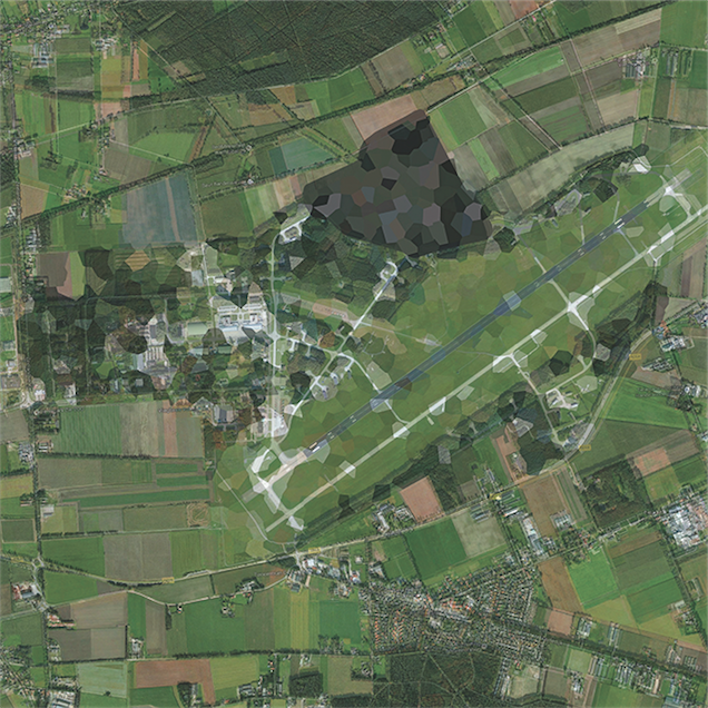
Burrington tells The Creators Project that some of the images in Reconnaissance are screenshots of Google Maps and Mapbox satellite imagery, stitched together, while most of them originate from the United States Geological Survey’s EarthExplorer website. The composites also feature artifacts such glitches and intentionally obscured areas of the images, as can be seen in the photographs of Volkel Air Base and De Peel Air Force Base.“To some extent I kind of had to compromise image selection around getting both the zoom level I wanted and getting images that were big enough for 1mx1m prints,” she says. “If you're using just Landsat that's pretty trivial, but for a lot of the sites I was looking at you had to be pretty damn close up to have any meaningful level of detail, so sometimes I was stitching together that imagery as well.”
De Peel Air Base (51.5196, 5.8532), 2015, Ingrid Burrington. Lenticular print, 100 x 100 cm
.Burrington’s goal here, apart from showing that “the view from nowhere doesn’t emerge from nowhere,” but is the result of decades of aerospace and electrical engineering research and development, is to merge the aerial aesthetics of machine vision with grounded infrastructures. To create an umbilical cord, so to speak, between the satellite technology launched into orbit with the data centers that store and circulate aerial and other kinds of information. See more of her works below:
Edwards Air Force Base (34.8190015, -117.853113), 2015, Ingrid Burrington. Lenticular print, 100 x 100 cm.
NATO's JFC Brussnum (50.945592, 6.00086), 2015, Ingrid Burrington. Lenticular print, 100 x 100 cm.
Moncks Corner (33.064257, -80.0443453), 2015, Ingrid Burrington. Lenticular print, 100 x 100 cm.
ONE EMAIL. ONE STORY. EVERY WEEK. SIGN UP FOR THE VICE NEWSLETTER.
By signing up, you agree to the Terms of Use and Privacy Policy & to receive electronic communications from Vice Media Group, which may include marketing promotions, advertisements and sponsored content.