

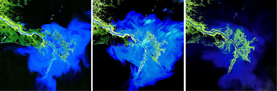
Landsat 9 natural color image (Bands 4, 3, 2) of the Bangladesh coastline on the Bay of Bengal acquired on February 8, 2022. Image: Michelle A. Bouchard, using Landsat data from the USGS
ABSTRACT breaks down mind-bending scientific research, future tech, new discoveries, and major breakthroughs.
Advertisement
Advertisement

Landsat 7 and Landsat 8 images of record flooding along the Gulf Coast of Texas caused by Hurricane Harvey, August 2017. image: NASA/USGS

Eastern Kazakhstan, captured by Landsat 8. Image: NASA/USGU
Advertisement

"The Eye of the Sahara" near the western edge of the Sahara Desert, captured by Landsat 8. Image: NASA/USGS
Because Landsat has provided consistent calibrated coverage at no cost for decades, it is “a really powerful tool for understanding the impacts of climate change in many, many ways,” Irons said, citing observations of “retreating glaciers, Amazonian deforestation and forest disturbance, urban growth, changes in ecosystems” which “are all reflective of climate change—the list is huge.”“For me, as someone who works in the coastal zone a lot, I see a lot of changes happening,” Fatoyinbo noted. “Both deforestation and coastal change are two really shocking images when you see them.”
Advertisement
Irons also remarked on the interesting experience of beholding familiar stomping grounds from space. When I asked him if he had a favorite Landsat image, he cited an early picture from the program of the Appalachian Mountains around Harrisburg, Pennsylvania. Through Landsat’s perspective, he recognized places he had hiked and identified geological features he had learned about in courses at Penn State.“To have it presented as an image taken from space, where the textbook discussion of what the Ridge-and-Valley looked like was right there, in a plain image that you could look at, explore, and say ‘oh, I hiked here’— that always struck me,” he said. “Our focus, appropriately now, is on anthropogenic effects on the land and on the world, and we spend a lot of time looking at the aftermath of disasters, wildfires, and urban growth, but sometimes it's good just to go back to those ‘Earth as Art’ images and realize the stark beauty of observing the Earth from the high vantage-point of space,” Irons concluded. “We can’t all be astronauts and have that view, but we can all look at Landsat data and imagine what it would look like if we were up in space.”